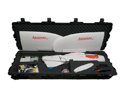
Aeromapper Talon Amphibious
The Aeromapper Talon Amphibious allows maritime operations by autonomously belly landing on water, or any surface. It's the perfect solution for aerial observation, data collection & situational awareness thanks to its high definition gyro-stabilized cameras with long range video transmission.
As ship-board maritime drone applications continue to expand, small multirotor drones fall short due to its limited range and endurance, and more complex VTOL systems are fragile, complex, and extremely challenging to land on a ship’s deck while at sea. The Aeromapper Talon Amphibious, with its ultra-durable and compact design, masterfully overcomes these limitations. Its cutting-edge water-landing capability provides a dependable and streamlined solution, bypassing the pitfalls of conventional VTOL setups.
Engineered for peak performance, the Aeromapper Talon Amphibious sets a new benchmark for maritime UAV operations. It excels in shipboard, coastal, and offshore deployments, seamlessly adapting to the demands of advanced aerial observation and data collection. The latest upgrade features a twin-engine power system, delivering exceptional reliability and making hand-launches incredibly straightforward.
The Aeromapper Talon Amphibious is a Transport Canada Compliant drone.


")

Up To 2 hr Endurance
BVLOS Capable (+30 km link range)
Multi-payload & customisable
40 Km/h Wind Resistance
Fully autonomous
Why Choose The Aeromapper Talon Amphibious
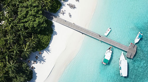
Explore the ultimate solution for advanced aerial surveillance and data acquisition in diverse maritime applications with our unique water-landing long endurance unmanned aerial system. The Talon Amphibious fixed wing sUAS is expertly crafted for seamless operation in shipboard, coastal, and offshore settings, excelling in surveillance, search and rescue missions, and environmental monitoring. Use lakes, rivers and oceans to your advantage.
With precise autonomous navigation, up to two hours of flight endurance, ultra-accurate water-landings, and exceptionally fast & uncomplicated deployment from tight spots such as boats, this versatile maritime UAV ensures effortless drone implementation for many organizations. It is fully autonomous from launch until landing, with a multitude of guidance methods available to the operator to maximize efficiency when patrolling or surveying very large areas.
Ideal for surveyors, researchers, emergency responders, and conservationists, this drone is invaluable for river and coastal mapping, wildlife tracking, marine resource management, water system monitoring, situational awareness and more. The Aeromapper Talon amphibious comes in an affordable package and its components are modular and future-proof. Its rugged and durable construction allows for repeated use and tough handling.
How does it work? The Aeromapper Talon Amphibious is expertly engineered for full waterproofing and unrivaled buoyancy, making it virtually unsinkable. Its internal architecture allows for rugged protection against salt-water environments. Each component is carefully protected against water and corrosion.
It can accurately belly land automatically on any surface like water, grass, dirt, gravel, etc.

Since its inception in 2018 by Aeromao Inc., the Aeromapper Talon Amphibious has built an exceptional reputation for performance and reliability, excelling in diverse maritime operations across the globe. Designed primarily for surveillance, reconnaissance, and observation, this cutting-edge UAV is optionally equipped with highly versatile, cost-effective gyro-stabilized 3-axis high-resolution cameras, offering various levels of zoom.
These advanced camera systems, seamlessly integrated with a fully digital high-definition video transmission system boasting an impressive 24-kilometer range, deliver unparalleled operational flexibility. Whether monitoring vast expanses of ocean or capturing intricate details of vessels, wildlife, or individuals, the Aeromapper Talon Amphibious empowers users to loiter over key areas of interest, zooming in for precise, real-time imagery.
With its proven track record and superior capabilities, the Aeromapper Talon Amphibious redefines maritime observation, offering a powerful, efficient, and reliable solution for professionals seeking excellence in aerial operations.
Talon Amphibious Key Features
Optimized for Beyond Visual Line of Sight (BVLOS) missions, the Aeromapper Talon Amphibious offers over 30-40 km of control and telemetry link range. Its integrated ADS-B module ensures safe airspace sharing by reporting the location and altitude of nearby manned aircraft in real-time.

Maintain continuous focus on your target with ease. The Aeromapper Talon’s remarkable flight endurance, combined with its ultra-clear long-range digital video downlink system, allows you to loiter over points of interest indefinitely. With a transmission range of up to 24 kilometers, you’ll experience unparalleled clarity and reliability, ensuring no detail goes unnoticed.
Building on the proven success of the Aeromapper Talon, the Amphibian variant inherits the same trusted design that has captivated over 300 customers across 45+ countries. Now featuring an upgraded twin-engine setup, it ensures flawless, effortless hand launches every time, regardless of the conditions.

The Aeromapper Talon Amphibious has a waterproof rating of IP67 (dust tight and protected against immersion). Even in the event of water ingestion, the internal components are individually protected. The system is made to last and support abuse in tough marine environment.
Discover extraordinary success stories showcasing the Aeromapper Talon Amphibious in action, tackling real-world maritime challenges across the globe. Trusted by private enterprises, government agencies, universities, and conservation groups, its unmatched capabilities and our exceptional customer support have ensured mission success, anywhere on Earth. We don’t just support your projects—we become your biggest fans, offering unlimited assistance to help you achieve your goals.


ID remote is now available on request. Comply with USA and Euro requirements for remote ID. We are official dealers of Dronetag Remote ID solutions.
- Construction: EPO foam (durable, easy to repair, carbon fiber reinforced).
- Wingspan: 2 m.
- Weight: 4400 grams.
- Endurance: 2 Hours.
- Launch: Very easy to hand-launch.
- Takeoff: Fully automatic.
- Landing: Automatic belly landing on water on any surface.
- Range: +30kms. Tested in real BVLOS flight operations (Beyond Visual Line of Sight).
- Max. Altitude: About 4500 masl.
- Cruise speed: 58Km/h.
- Flight modes: Manual, Stabilize, Return to Home, Fly be Wire (automatic holding altitude and airspeed), Auto.
- Wind Tolerance: up to 40 km/h.
- Maximum speed: +85 Km/h
- Failsafe: Automatically returns to home & loiter upon loss of RC link. Other fail-safe routines available.
- Telemetry: Battery status, alt, ground speed, compass, altitude, distance traveled, time on air (speech enabled), and more than +200 parameters more.
- Moving map display/telemetry: Drone position and heading, commands on map, fly to point on map, altitude changes, remote spot camera trigger, mission route, and more.
- Weather: All-weather performance. -20°C to +40°C.
- Aeromapper Talon Unmanned System Ready to Fly.
- One set of batteries for 2 hrs of flight time.
- +30 Km Link system.
- ADS-B live air traffic data system.
- Lipo Battery Charger.
- User’s Manuals & Documentation.
- Heavy duty carrying cases.
- Mission Planner Software.
- Unlimited Support after sale.
Optional Additions and Pricing
Aeromapper Talon Amphibious complete UAV system, flight tested and ready:
- Aeromapper Talon Amphibious Unmanned System.
- One set of batteries for 2 hrs of flight time with charger.
- +30 Km Data Link system.
- ADS-B live air traffic data system.
- Heavy duty carrying case.
- Mission Planner Software.
- User’s Manuals & Documentation.
- 12 month warranty AND Unlimited Support after sale.

4K 8Mp HD 6X Digital zoom 3-axis gimbal
4K video, 8Mp photo Ultra HD 3-axis stabilizer camera. Very compact and lightweight. 1/1.7 Inch Sony CMOS sensor. This is a basic camera at an extremely attractive price point. Allows slightly longer endurance on the Aeromapper Talon due to its compact design and ultra light-weight.
More info
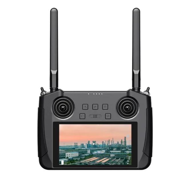
HD Long – Range digital video donwlink
The New HD digital long range video downlink system offers a crisp sharp real-time video to distances of up to 24kms, low latency. The system includes the video transmitter, video receiver with 5.5inch display and long range antennas.
Online flight training
Comprehensive Online flight training covers everything needed to operate the UAV such as pre-flight checks, mission planning, maintenance.